Sunday, April 25, 2010

Sustainable Building Products Exhibition in Sydney

Along with the architecture conference at Darling Harbour in Sydney last week, there were the exhibitions: DesignEx, Form and Function, D4S: Design for Sustainability.

One notable products were Smart Glass from iGlass Australia: this is glass which is translucent until a current is applied when it become clear. The glass can be used as a projection screen. The obvious application I can see for it is in a learning center, where smaller rooms can be made private at the flick of a switch. This is much easier than moving hinged or sliding walls, or lowering blinds.

A slightly older products is marble from Ionia Stone of Turkey.

Ecoglo showed glow in the dark safety products, including non slip edges for stairs. Unfortunately the standards for illumination of exits administered by Standards Australia assume that lighting will be provided by battery powered lights and therefore does not allow for luminous material (New Zealand standards are more advanced). I asked about luminous tactile paving, Ecoglo have designed these but are awaiting standards approval. The idea is that the same floor marking which are used to guide the blind by touch (through a cane) can be used in the dark by sighted people.

Exeloo showed their computer controlled self cleaning public toilets. These report back to a central monitoring facility, not only any faults, but on the consumption of power and water.

Computronics showed their RGB Screens, these are daylight readable large LED screens for outdoor use. They are capable of displaying video as well as diagrams and text. This could be useful for an outdoor classroom.

Safety Floorings were showing recycled non-slip floor coverings. I asked about running cables under the coverings and Luke Doran recommended EcoTile's Cable Access Flooring. This consists of recycled polypropylene tiles which have feet molded on the underside. These are laid directly over the existing floor, leaving enough space to run cables. Carpet or other tiles can then be laid over the top.

Labels: ,

Friday, March 26, 2010

Sahana First AGM

The first annual meeting of the the Sahana Software Foundation for members and directors will be in Washington USA, 2 May 2010. This is in conjunction with the 7th International Conference on Information Systems for Crisis Response and Management.

As a member, I will attend the meeting by web conference (unless someone would like to buy my air ticket). The meeting starts at 15:30 GMT, which is 1:30:00 AM Canberra Time (3 May 2010) . This reminds me of the inaugural meeting of the Internet Society of Australia, which I attended remotely from Cambridge (England) where it was about 4am and pitch black.

The agenda will look something like the following:

  08:00 Breakfast
08:30 Members Meeting
Report of Officers to the Members
Review of Nominations of New Members
Election of New Members
Review of Nominations for the Board of Directors
Election of Board of Directors
General Discussion
12:00 Lunch
13:00 Sahana Symposium/Mini-Conference
15:30 Breakout Meetings of Committees and Projects
17:00 Adjourn
18:00 Dinner Meeting of the Board of Directors

From: first annual meeting of the the Sahana Software Foundation, 2010

Labels: , ,

Thursday, March 25, 2010

Atlantic and Pacific Tsunami exercises under way

Tsunami exercise "LANTEX 10" commenced at midnight GMT today, with the first message sent by the West Coast/Alaska Tsunami Warning Centre. This is a scripted exercise to test tsunami response plans. LANTEX 10, simulates a magnitude 7.5 earthquake off the New England coast. Detail of the exercise, including the timeline of what is scheduled to happen when is available in the LANTEX10 Handbook Version 3.0.

There is also the corresponding Pacific exercise PACIFEX 10, simulating a magnitude 9.0 earthquake south of the Alaska Peninsula. Details are in the PACIFEX10 Handbook Version 3.0. In addition Alaska and California are conducting tests of their Emergency Alert Systems, including on TV and radio the same day.

It should be noted for those used to more free flowing exercises, as used by the UK and Australia, the US exercises tend to be more tightly scripted.

ps: Also note, as it says in all messages issued: THIS IS ONLY AN EXERCISE.

Labels: , ,

Tuesday, March 16, 2010

Commercial Emergency Alert Services

In the last day I have been contacted by two companies offering emergency alert services in Australia to governments, schools and companies. These are the Early Warning Network from Kerry Plowright's Look Here Pty Ltd and Emergency Contact from OnCall Messaging. These seem to have been promoted by the recent run of weather related emergencies in Australia. In theory the Australian state and federal governments now provide phone, text message and broadcast emergency warning services, but as I have detailed previously, these leave a lot to be desired, so there is room for commercial providers.

Labels: ,

Sunday, March 07, 2010

Australian Tsunami Awareness Review

Yesterday, the Attorney-General, Robert McClelland, announced a Tsunami Awareness Project, and a review of the public response to tsunami warnings. These are of limited value due to a lack of detail about the review and restrictions placed on distribution of the awareness campaign materials by the Attorney.

"Tsunami Education and Awareness" is a CD-ROM and web site distributed by Surf Life Saving Australia. The Attorney says he has written to Emergency Services Ministers and Surf Life Saving Organisations requesting a review of the public response to tsunami warnings. It is not clear who is conducting the review, what resources have been made available for it or when it is to be completed. The Attorney did not release the proposed terms of reference for the review.

While Australia has a well designed and run Joint Australian Tsunami Warning Centre (JATWC) provided by the Bureau of Meteorology and Geoscience Australia, there is no national system for the warnings to be distributed through government agencies, nor a response coordinated. Warnings are sent to an ad-hoc arrangement of state organisations and then to an assortment of local bodies. It is not surprising that the public may take little notice of the resulting confusing and contradictory messages they get as a result.

An example of the lack of effort for Tsunami warning is show by the Queensland Government's "Queensland Tsunami Notification Protocol" (Version 1 , 9 December 2009). This has been distributed as a 9 page 3.7Mbyte PDF document, scanned from a paper original. As a result the text of the protocol cannot be found with a search or copied for use. The protocol contains such outdated procedures as the JTWC contacting Queensland by telephone before issuing a Tsunami warning. This is not an acceptable procedure as it would delay the issue of a warning and risk public safety. The protocol assumes a 90 minute warning for a Tsunami. However, situations can arise much more quickly, which would place emergency personnel in the ethical dilemma of either following procedures or ignoring them to issue a timely warning. The Protocol does not specify how agencies within Queensland are notified. Based on previously experience of a Tsunami warning in Queensland, it is not clear the Queensland Government has a system for coordinating a response.
The review will be conducted with State and Territory Emergency Services Agencies, Local Governments, surf life saving organisations and other stakeholders and will focus on:
  • ways to better educate and prepare the public for, and improve its response to, future tsunami warnings, and
  • mechanisms for the effective distribution of tsunami warnings to the public. ...
From: Tsunami Awareness Project, Media Release, Attorney-General, Robert McClelland, 6 March 2010
Tsunami Education and Awareness Material

The distribution of the awareness material distributed by Surf Life Saving Australia will be greatly hampered be the Attorney's decision to ban making copies. The Attorney has imposed copyright restrictions on the material banning the making of any copies without written permission of the federal government. The Attorney could have instead used a Creative Commons licence, freely allowing not-for-profit distribution.

Tests on the main menu page of the awareness kit show:
  1. No HTML Validation Errors.
  2. Score of only 35/100 with the W3C mobileOK Checker. It would be very useful for such a awareness program to be compatible with mobile phones used by young people.
  3. On an automated accessibility test (TAW 3.0 for WACG 1.0) the page had zero Priority 1, sixteen Priority 2 and 4 Priority 3 problems. It would be useful if the page at least met current Australian guidelines for accessibility of web sites by the disabled.
Table of Contents of the Awareness Campaign

Labels: , ,

Friday, February 12, 2010

APCO Emergency Communications Conference in Melbourne in March

The "2010 APCO Australasia Conference & Exhibition" is in Melbourne, 15-17 March 2010. The theme is "Technologies & Their Impact on Major Emergencies, A Case Study: Back to the Future – Black Saturday". Last year I attended, and presented, at the conference in Sydney, during the Victorian brushfires, along with people responsible for fighting the fires. This is a very useful conference for those in the emergency and security communications business.

STREAMS INCLUDE:

• Counter-Terrorism
• Critical Infrastructure
• Emergency Management & Response
• Future Technologies
• Information & Contract Management
• Training, Education & Planning
• Interoperability
Some 2010 Key Presenters Include
  • David Thodey, Chief Executive Officer, Telstra Corporation
  • Tony Pearce, Director General Emergency Management Australia
  • Kyle Tyrrell, Lieutenant Colonel, Australian Defence Force
  • Simon Overland, Chief Commissioner, Victoria Police
  • Russell Rees, Chief Officer, Country Fire Authority Victoria
  • Greg Sassella, Chief Executive Officer, Ambulance Victoria
  • Christine Nixon, Head of the Victorian Bushfire Reconstruction & Recovery Authority
  • Michael Hallowes, Head of Strategic Operations, National Policing Improvement Agency UK
  • Jolly Wong Chun-Kau, Chief Telecom Engineer, Hong Kong Police Force
  • Bruce Farr, Chief, Toronto EMS
  • Dr. David Boyd, Director of Command Control and Interoperability, Department of Homeland Security USA
  • Dr David Jones, Head of Climate Analysis National Climate Centre, Bureau of Meteorology
  • Dr. John Carnie, Chief Medical Officer Victoria
  • Dr David Borth, Chief Technology Officer, Motorola
  • Mike Wright, Executive Director - Wireless Engineering & Operations, Telstra Corporation

Labels: , , , ,

Thursday, February 11, 2010

Global Humanitarian Software Foundation

The Sahana Software Foundation has announced its initial membership to guide work on software to assist in disaster relief operations around the world. There are two Australian members: Don Cameron and myself.

The Sahana free open source software was written for relief operations in Sri Lanka after the boxing day tsunami. It has been expanded for use around the world, winning some awards along the way.

The 24 members from USA, UK, Sri Lanka, Canada, Sweden, Denmark and New Zealand. will be voting for a Board of Directors in May, to run the organisation. The process has been delayed as many of the volunteers are busy providing software and systems to support the relief effort in Haiti.

My role in Sahana has been limited to providing some advice on the use interfaces for the system (and teaching this to my ANU web design students). But every little bit helps and I encourage others to join in.
Sahana Software Foundation
FOR IMMEDIATE RELEASE

SAHANA SOFTWARE FOUNDATION ANNOUNCES INITIAL MEMBERSHIP

LOS ANGELES, CALIFORNIA, 10 February 2010: The Sahana Software Foundation announced today its initial membership. Membership invitations were extended in December 2009 to current and past board and project management committee members. Those who accepted this invitation and form the initial membership of the Sahana Software Foundation are:

David Bitner, USA
Fran Boon, UK
Ravith Botejue, Sri Lanka
Don Cameron, Australia
Mifan Careem, Sri Lanka
Trishan de Lanerolle, USA
Chamindra de Silva, Sri Lanka
Ravindra de Silva, Canada
Sudheera Fernando, Sri Lanka
Mahesh Kaluarachchi, Sri Lanka
Dominic König, Sweden
Ishan Liyanage, Sri Lanka
Greg Miernicki, USA
Darmendra Pradeeper, Sri Lanka
Mark Prutsalis, USA
Louiqa Raschid, USA
Eric Rasmussen, USA
Martin Thomsen, Denmark
Gavin Treadgold, New Zealand
Nuwan Waidyanatha, Sri Lanka
Sanjiva Weerawarana, Sri Lanka
Brent Woodworth, USA
Tom Worthington, Australia

Members of the Sahana Software Foundation are eligible to nominate new members and to vote for the composition of the Board of Directors and other issues at the annual meeting of members. The first meeting of the members of the Sahana Software Foundation is scheduled for May 2010 at which the first elected board will be voted on, followed by a board meeting.

The current board is composed of Mifan Careem, Chamindra de Silva, Darmendra Pradeeper, Mark Prutsalis, Louiqa Raschid, Martin Thomsen, Gavin Treadgold, Sanjiva Weerawarana and Brent
Woodworth.

The officers of the Sahana Software Foundation are:

Brent Woodworth (Chair), Mark Prutsalis (President & CEO), Chamindra de Silva (Secretary & CTO), and Dale Zuehls (CFO/Accountant).

The governing bylaws of the Sahana Software Foundation can be reviewed at: http://wiki.sahana.lk/doku.php/foundation:home#bylaws

About the Sahana Software Foundation:
The Sahana Software Foundation was established in June 2009 as a non-profit membership-based organization, and governs the free and open source software Sahana disaster management system.

For more information, contact:
Mark Prutsalis, President & CEO
Sahana Software Foundation
Tel +1-860-499-0332
mark@sahanafoundation.org
http://www.sahanafoundation.org
###

Sahana Software Foundation
900 Wilshire Blvd, Ste 1500
Los Angeles, CA 90017
http://www.sahanafoundation.org

Labels: , , ,

Thursday, January 21, 2010

Australian High Speed Ship to Transport Haiti Aid

High speed catamaran Alakai sister ship to Huakai in HawaiiThe US government is deploying the Australian designed 113 metre high speed catamaran “Huakai” to assist with Haiti relief. Completed last year as a vehicle ferry for Hawaii, the ship can carry up to 800 tonnes at 40 knots. It has a shallow draft of 3.7 m, water jets and 20 metre ramp, allowing it to dock and unload without assictance. It is likely the ship will shuttle between Haiti, Guantanamo Bay and Miami.

A similar operation was carried out by the high speed catamaran HMAS Jervis Bay, operating between Darwin and East Timor from 1999 to 2001. Like Huakai, this was a surplus commercial ferry taken up for government use. The US military were impressed with this and leased a number of Australian designed catermarans.

The US Department of Defence has contracted Austal (who built the Huakai), to build up to ten similar "Joint High Speed Vessels" (JHSV) for military transport. The first named “Fortitude” (JHSV 1) is being constructed in the USA. Tjhis will be followed by Vigilant (JHSV 2) and Spearhead (JHSV 3).

Labels: , , , ,

Monday, January 18, 2010

Haiti 2010 Sahana Disaster Response Portal

The Sahana Software Foundation have created the  Haiti 2010 Sahana Disaster Response Portal, with feeds from many relief agencies and software to coordinate the relief effort for the earthquake.


Labels: , ,

Friday, January 08, 2010

Social Networking Technology for Emergencies

Cover of New Technologies in Emergencies and ConflictsThe United Nations Foundation has released "New Technologies in Emergencies and Conflicts: The Role of Information and Social Networks" (2009). The full report is available online, as one donw load and by chapter. The report recommends remove regulatory barriers for better early warning and emergency response and putting more resources into
local preparedness. The call for standardisation of communications is timely, including a global standard for cell broadcast technologies. Australia is entering another bushfire season with limited standardisation of systems at the national level. The report has received some criticism on the Humanitarian ICT discussion list for the breadth of coverage, but such a report can include online a limited amount of material.
  1. Foreword
  2. Acknowledgements
  3. Executive Summary
  4. Introduction
  5. Alerts: Early Warning And Communication Needs
  6. Preparedness: Building Communities’ Resilience
  7. Response: Coordination In Emergencies
  8. Rebuilding: Post-Crisis Services And Development
  9. Recommendations
  10. Endnotes
Executive Summary

Natural disasters and violent conflicts have always been part of human existence. But the number of humanitarian crises has been rising in recent years. Moreover, disasters strike
most frequently, and with the most devastating impact, in the least developed countries. These countries also have the weakest communications infrastructures, which poses a
particular challenge to governments, aid agencies, and the affected population at every stage of a crisis, from the runup to a disaster through to long-term reconstruction.

There have been dramatic advances in communications technology: in the number of new technologies, the mobility and range of functions available, and the spread of these technologies. Growth has been particularly strong in the penetration of mobile phones and more recently the uptake of social networking websites including Facebook and Twitter. One important change is a shift from one-to many forms of communication, such as television and radio, to many-to-many forms of communication, such as social
networking and crowdsourcing websites, that is changing the way in which information is delivered and exchanged.

Communications advances present an opportunity forhumanitarian organizations to harness modern technology to communicate more effectively with communities affected by disasters and to allow members of those communities to communicate with each other and with the outside world.

People in affected communities can recover faster if they can access and use information. A look at the use of communications technology during disasters in recent years shows
that while it has played a positive role, its full potential has not yet been realized.

Moreover, governments, humanitarian agencies, and local communities face challenges and risks associated with modern technological innovation. These include:

• Information flows must be two-way to be effective — from the external world to the affected community, but also from those affected to the agencies seeking to help
them in useful ways.
• Information will not be used unless it is trusted. The utility of any technologies will depend on the social context. People are a vital part of the communication system. ...

Recommendations ...

Remove regulatory barriers
Some regulatory barriers to effective early warning systems and emergency response remain, despite the great progress made in these aspects since the Indian Ocean tsunami. We identified:
• the need for further standardization of communications in emergency situations—such as a global standard for cell broadcast technologies, for example;
• the need to develop standards applicable to existing and future systems for delivery of early warnings or alerts;
• the need for inter-operability between public networks and networks dedicated to emergency communications; and
• a need for priority access by emergency services personnel to communications.

Furthermore, governments must extend the regulatory framework to new and emerging technologies. Regulation is lagging behind innovation. In particular:
• the international community needs to create a legal framework enabling the use of unmanned aerial vehicles, which hold great promise for collecting information for
use by humanitarian agencies but are currently unable to be deployed due to legal uncertainties.

Put more resources into local preparedness
People-centeredness has been one of the themes of this report. The people affected by an emergency are in the best position to know what is happening and what they need.

Preparedness requires long-term investment by humanitarian organizations, including investment in public education and capacity building in local media.

Information provision should be recognized as a standard part of both preparedness and aid delivery, and might include:
• preparation of off-the-shelf material agreed on between humanitarian and aid agencies (what to do in an earthquake, basic sanitation advice, for example);
• training humanitarian agencies in communication skills, including receiving and using feedback from communities; and
• the inclusion of a wind-up radio in aid packages.

Information needs to be collected and deployed to be effective. Often this will be done by official agencies, but their responsibilities may be overlapping and uncoordinated.
Preparedness also requires the international humanitarian community to be able to act themselves in a coordinated way on the information and analysis enabled by these emerging systems.

Agencies should share best practices with each other.
Agencies developing tools for use in disaster preparedness and emergency relief should also include consideration of their potential for communities’ post-disaster or postconflict needs, to leverage the investment of resources as effectively as possible.

Governments—especially in developing countries where access is not ubiquitous—also need to consider enhanced access to communications and investment in infrastructure, among all the competing demands for resources.

Leverage new media and crowdsourcing
Some of the most promising applications of new technology in emergencies use social media, often through crowdsourced applications.

As this report has shown, the issue of authentication is a key barrier to overcome. The development of methods and applications for verification of crowdsourced information
should be a priority. The humanitarian community can support the development of innovative platforms that addres the issue of verification as well as provision of information by users.

At the same time, it is important to ensure that communications technologies can offer their users a sufficient degree of anonymity and protection. This will depend on
technological solutions but also, importantly, the legal framework and public debate about the risks as well as benefits of anonymity. ...

From: New Technologies in Emergencies and Conflicts: The Role of Information and Social Networks, United Nations Foundation, December 2009

Labels: , , ,

Friday, December 18, 2009

Problems with ACT Emergency Services Agency web site

In response to my posting about accessibility problems with the Victorian Government Country Fire Authority Web Site, a commenter has noted similar problems with the ACT Government's bushfire web site. I was unable to access the ACT Emergency Services web site thismorning. However, I was able to see the Google cache copy from 17 Dec 2009 10:04:58 GMT.

An automated (TAW) accessibility test reported zero Priority one, 67 Priority Two and 13 Priority Three problems with the ceched page. The W3C Markup Validation Service reported 42 Errors and 57 warning with this page. The page failed the W3C mobileOK Checker test. Obviously some of these problems may be due to using the cache copy, which is slightly modified from the original. But given the real site is not avialable, this is a valid test.

I suggest the ACT Government fix their web site, before more lives are lost to bushfires in Canberra.

Labels: , , ,

Thursday, December 17, 2009

Cautionary Tales of Inaccessibility Not Learned by Victorian Government

The W3C Web Accessibility Initiative (W3C WAI)has released a set of "Cautionary Tales of Inaccessibility" to help promote good web design. I was contacted about details for "A Cautionary Tale of Inaccessibility: Sydney Olympics Website". Regrettably the Victorian Government Country Fire Authority Web Site may be added to this list. An automated test indicates that the CFA home page failed a W3C WAI Version 1 test, with 1 error at level 1, 36 at level 2, and 15 at level 3. The page also failed a W3C HTML Validation test, with 230 errors and 37 warnings. The page also failed the W3C mobileOK Checker tests.

The 2009 Victorian Bushfires Royal Commission identified deficiencies in the online distribution of bushfire information by the Victorian Government. Some media reports indicate that the CFA web site failed yesterday.

Any ICT professional involved with bushfire web sites must be aware that they have ethical as well as legal obligations to ensure that the systems they provide are operating correctly. Arguing that the web site is not essential and that citizens can get information from radio or other sources is not a valid defence, nor is arguing that they do not have sufficient resources, nor that they did not have the authority, or were ordered not to fix the flaws in the system. Professionals are required to act in the public interest, regardless.

The design of web sites for emergency use, including in bushfires is not a new field and there are some established approaches. I outlined some of these, along with methods of using the web for investigations, for the staff of the Victorian bushfire inquiry:

Role of ICT in Emergency Management

Labels: , , ,

Sunday, December 06, 2009

Hybrid Trucks for Local Council

Leichhardt Council in Sydney has purchased a Hino Hybrid Truck fromToyota's truck subsidary, which uses similar techology to Toyota's Prius hybrid car. In stop-start traffic, such a truck uses 20 l/100km, which is a considerable saving. Adapting this technology for trucks has taken a long time. The decision to purchase the truck was made in 2004 (Motion C465/04 by PARKER/HAMILTON, MINUTES of ORDINARY MEETING of Leichhardt Municipal Council , 23 November 2004), but it has taken until 2009 for the vehicles to be readily avialable.

In his 3 December Mayoral Column ("New Hybrid Truck Helps Cut CO2 Emissions in Leichhard"on page 12 of the Inner West Courier) , Mayor of Leichhardt, Counsellor Jamie Parker, reported on the purchase of the truck for garden maintenance.Unfortunately the Mayor's message contains a typographical error in that it refers to the truck reducing Carbon Monoxide emissions by 72%. This should read "Carbon Dioxide", as indicated by the chemical symbol in the report (CO2).

Also it is not clear that a hybrid truck is not particularly suited to garden maintenance, as the Mayor suggests. Hybrid vehicles achieve greatest savings when operating at low speed in stop start traffic. A good example of such an application are garbage trucks, which stop every few metres and rarely exceed a few kilometers an hour. Local busses are another example. In contrast a garden maintenace truck spends most of its time stationary with the engine turned off, while the garden work is being done. As a result little saving is made in fuel use.

This is a good initiative, but the council might like to consider other uses for it. These trucks have a useful role by providing electrical power. One use would be for powering the hot water weed killing unit often used for roadside weeds. These are usually powered by a diesel generator mounted on the truck. With a hybrid truck the generator could be eliminated.

The council could also use the truck as an emergency generator for its disaster response. . Usually diesel generators are used for this role which require ot be specially purchased, maintained, fuelled and tested, which is expensive and environmentally unfriendly. Instead the council could have the hybrid truck fitted with a socket to allow its generator and batter to supply electrical power. This could be used for extended and extensive blackouts at council premises. It could also be used to power a mobile emergency facility., such as those provided by Salvation Army Emergency Services (SAES). The truck could also be used for power at council work sites and at community functions in parks where mains power is not avialable. The Petersham Tafe are experienced in the development of alternative power systems and should be able to advice how to do this.

Labels: , , , ,

Tuesday, December 01, 2009

Emergency Communications Conference Call for Papers

APCO Australasia have issued a call for papers for their 2010 conference on emergency communications , 14 – 17 March 2010 in Melbourne. The 2009 conference was held during the 2009 Victorian Bushfires (I presented on Community Warning Systems) and emergency communications for bushfires will again feature in the 2010 conference.

Labels: , , ,

Saturday, November 28, 2009

National Emergency Alert system from next week

The Victorian Premier has announced that the National Emergency Alert system had been tested and will be ready for use next week. Unfortunately there is no emergency information system to back this up with detailed information about the emergency. As a result the National Emergency Alert system is of little value and may cause more harm than good.

The system, developed by Telstra, was previously called the National Emergency Warning System, and can deliver 300 text messages per second and 1000 voice messages per minute.The initial system will use the registered address of the telephone or mobile service and so not be able to target travelling users.

A test recorded audio message was sent containing the Australian Standard Warning Signal. The test text message was:

+6144 444 444

EMERGENCY TEST MESSAGE from the Victorian Government to test the new telephone emergency warning system NO ACTION REQUIRED For more info www.oesc.vic.gov.au

In neither case was the recipient required to take any action. Reception was gauged by random phone poll afterwards. The Victorian government has not released the results of the test. The Victorian Premier should release the results of the test for independent and public review.

Unfortunately the web site people referred to is a policy and administrative one, and contains no useful information about actual emergencies. Having a system which can deliver an emergency message is of little value unless those warned can be referred to more detailed information relevant to the specific emergency. The Victorian government needs to follow the practice adopted by the ACT Government and have a web page specifically about current emergencies.

Labels: , , ,

Thursday, November 26, 2009

Emergency 2.0 Australia

Emergency 2.0 Australia, is part of the Australian Government 2.0 Taskforce looking at how Social Media can assist in Emergency Management. In my view Social Networking, the Internet and web, have a useful role in emergency communications. However, disaster management using IT needs to be carefully planned and tested.

The Emergency 2.0 Australia website is incorrect in suggesting that the February Victorian Bushfires saw the emergence of the use of social media and web2.0 technologies. The disaster just brought them to public prominence via the media. These were already being planned, tested and deployed elsewhere.

Labels: , , , , , ,

Wednesday, November 11, 2009

Lack of Australian emergency warning standard risks lives

Australian Fire Danger Ratings chart with levels: Low-Moderate, High, Very High, Severe, Extreme and Catastrophic (Code Red).For this bushfire season a new Australian National Emergency Warning System has been introduced. Unfortunately there appears to be no standard issued for the formatting of the messages and no harmonisation with other warning messages. As a result this will make it difficult to relay the messages quickly and reliably via media such as SMS. This could result in delayed, misleading or lost messages, with loss of life, as happened in the Victorian Brushfires last year.

After last season when more than 100 lives were lost in Australia a new "Catastrophic (Code Red)" level has been added. There will be increased use on radio of the radio of the Australian Standard Emergency Warning Signal. There are now three Alert levels and warning messages: "Advice", "Watch and Act" and "Emergency Warning".

What is required is a precisely defined format for the messages to be issued. This format must be compatible with the systems which will be used to transmit the messages, including SMS. The message format and language must be consistent with that of other warning messages, including Tsunami warnings. Failure to do this risks lives.

Labels: , , , ,

Wednesday, November 04, 2009

Hard Dry Cases for Mobile Phones

Witz Phone LockerAbout a year ago I was looking for a waterproof case for holding a mobile phone. The 50 Series Universal Hardcase from Tactical Tailor looked good, but is hard to get in Australia. Recently I came across the Witz Phone Locker, which appears similar. However, they do not appear to have as rugged clips as the TT. This size case would also be suitable for large MP3 players and smaller hand held GPS units . Most of the other Witz cases do not have belt clips (some are transparent, which would be useful). Also keep in mind that the dimensions given are of the outside of the case and what you can fit in them is considerably smaller.

Labels: ,

Wednesday, October 07, 2009

Emergency Operations Centre Specifications

The Nelson City and Tasman District Councils of New Zealand have issued a request for Expression of Interest for a Information and Communications System for a joint Emergency Operations Centre (EOC) (Reference: 27532). This is for emergency and disaster coordination.

The 23 pages of documentation (available to registered companies) includes a concise statement of requirements for such a system. Included is a photo of an EOC, equipped with about 13 computers and having about 20 people in it. In contrast to the usual publicity photos of such centres, this shows the messy reality. The requirements specification also shows a simialr grasp of the chaos which can occour in the early stages of an emergecy.

The documentation also specifies the current computer and telecommunications systems of the councils. These a re quite complex and the Councils might find it better to replace them with a more rationalised streamlined system, rather than try to make these systems suitable for emergency use. Recent advancements in thin client computers using VoIP allow low cost equipment to work at low power from low cost servers. This makes for a much simpler set-up than PCs and IP phones which will require more backup power, networking and servers.

Simple database applications with web based interfaces can be used. In many cases organisations spend considerable effort and money on systems to allow the emergency applications to run in standalone mode, in the event of server loss. In practice, most such systems will not work without the server and it is better to concentrate on a cheap, similar and reliable server system.

Also low power, low cost netbooks could be of use. These could replace more power hungry and expensive laptops. Smart phones with WiFi support may also be of use o supplement netbooks. These can form a useful transportable operations centre, with all the equipment needed for a dozen operators fitting in an airline carry-on size wheeled bag. A central server and WiFi base station would provide access for a dozen netbooks and smart phones. This could be used to supplement the fixed centre and the same location, be deployed nearer an emergency location or be used to replace the centre should it be disabled in the disaster.
Requirements

1.80. The EOC may need to operate under three general scenarios:
a. A local emergency with normal power and telecommunications
b. A local emergency with local interruptions to power and
telecommunications (in this scenario the EOC has its own power supply so ICT within the building can operate)
c. Significant emergency, could be Local, Regional or even a National Emergency with limited or no power supply or telecommunications, EOC could be running from one or two stand alone PCs or possibly have reverted to analogue (plus paper-based) systems 1.81. The EOC, when fully operational could be operating 24 hours a day for several days with 30-40 staff in three revolving eight hour shifts (see image below for an overall impression of what an EOC looks like).

1.82. The above image is of a mature EOC i.e. an EOC well into an emergency. When first activated, particularly in a declared emergency, the situation can be quite chaotic. EOC staff may start to arrive over the course of an hour or more and it might take some time for the EOC to reach ‘critical mass’.

Messaging

1.83. Once activated, several different personnel, though typically designated telephonists within the EOC will need to be able to simultaneously record incoming information. This will include messages from: members of the public phoning in, emergency services communications, reports via radio telephone and/or mobile phone from emergency management personnel on the
ground, emergency management personnel reporting face to face. The EOC personnel having those conversations need to be able to quickly record details of the conversation in a structured way.

1.84. Ideally the person taking the call will be able to choose from different situation choices based on what the caller is saying i.e. flooding, blocked road (and blocked by: slip, fallen tree, vehicle incident), call-taker is prompted by
the system about what questions to ask (possibly in a descending order of importance). Where applicable, responses can be tic-boxes.

1.85. Ideally the system will automatically assign metadata where appropriate i.e. date, time, user ID, machine ID

1.86. The use of geospatial aids (maps) is usual in EOC to aid visual representation of an emergency and as an aid to analysis of the situation. Emergency situations suit such analysis because typically incidents within a wider emergency occur at some location. To facilitate display and analysis within a
geographical information system (GIS) (during and subsequent to an emergency), in capturing those locations, the call-taker should be able to choose from managed lists the location that fits the description from the caller i.e. Address (18 Hampden Street, Murchison), Road Intersections (cnr Motueka Quay and Glenaven Drive, Motueka), Road (waimea Road, Nelson), Place or Places (Broadgreen House or Appleby School), River Segments (Washbourn Stream between Hill Street and Washbourn Drive or Motueka River between Woodstock and Stanleybrook).

1.87. Assigning criteria to calls: The person taking the call will need to be able to assign a range of different criteria to an individual message.
• Validation: Who was the caller? How reliable is their information? Was the caller ‘Joe Bloggs’, untrained and unqualified member of the public or a trained and experienced member of Emergency Services or an Emergency Management Field Operative? The information supplied by the latter would be rated higher than the former.
• Urgency: i.e. ‘routine’ through to ‘requires immediate attention’
• Importance: i.e. ‘routine’ through to ‘highest’
1.88. The system would be able to ‘flag’ or highlight individual messages based on a criteria i.e. ‘Red-Flag’ for urgent or important or ‘Blue-Flag’ for routine.
1.89. Have the capability to link or group one or more messages together.
1.90. Often in an emergency situation the EOC will receive multiple calls in a short span of times about the same situation. Rather than record this multiple times, it would be more efficient if you could record the same base information e.g. “Appleby Bridge approaches washed out”, then note the number of calls
received about that. Explain how the system might achieve this.
Request for Expressions of Interest to Supply

Workflow
1.91. Once the EOC call taker or team member has captured all the information regards a particular message, they need to be able to:
• Assign the message to an individual EOC team member
• Assign the message to an EOC team e.g. Planning and Intelligence
• Assign a message to multiple individuals and/or teams
1.92. The system routes a particular message via some form of workflow function to the assigned individual/s and/or team/s
1.93. In the event no individual/s or team/s are assigned to a particular message, the message can be configured to rout particular messages, based on a userdefined criteria to an individual or team based on one of the captured criteria
e.g. all messaged tagged ‘highest’ importance go to the Controller
1.94. Individuals and team can quickly and easily see/be alerted to/find messages assigned to them
1.95. Individuals and/or groups need to be able to add to a message. This may include adding additional information and/or comments. Assigning or reassigning status e.g. under action, closed, validation required, or assigning to an additional individual or team
1.96. Explain how the workflow function works.
1.97. Once messages have been processed have the ability to check or tag them in some way as ‘complete’ or ‘actioned’ etc. and they disappear from the ‘active’ list/screen but stay in the system.

Scalability/Portability
1.98. Could have the capability to be installed, stand alone within Councils smaller EOCs; Motueka, Takaka, Murchison but with the capability to communicate (integrate) with the main EOC
1.99. System can be scaled to monitor and/or manage the range response levels (from Introduction): Level 3 – Local Coordination; Level 4 – Regional Coordination i.e. the system may start off monitoring/managing a single incident which eventually escalates into a full emergency.
1.100. While for most emergencies it would be envisaged the system would operate within Councils existing ICT infrastructure (refer ‘Existing System & Environment section) because of the nature of emergencies it would also need the capability to run in a stand alone situation i.e. be network independent. How would that work?

Integration
1.101. External communication is an important component of an emergency response i.e. letting interested parties know about the status of the emergency; where evacuation points might be; what areas have been evacuated etc. The system would be able to communicate, preferably via standards-based protocols to external agencies/sites i.e. make available data/information feeds in standard formats e.g. Really Simple Syndication (RSS) or Extensible Mark-up Language (XML) or Keyhole Markup Language (KML). Consumers of such feeds could include: Nelson City and Tasman District Offices, Emergency Services (Fire, Police, Ambulance), National Crisis Management Centre,
National Health Coordination Centre. Explain capability for this.
1.102. The system might want the capability to utilise real-time data feeds using standard protocols from TDC and NCC core systems. How could that happen?
1.103. System would have the potential to integrate with Councils geographical information systems (GIS), specifically Environmental Systems Research Institute (ESRI) ArcGIS Server, through web services or other standardsbased integration methods.

How might that work?
Architecture
1.104. Please supply details of the systems architecture.
1.105. Explain how server/PC images, versions and upgrades could be managed particularly at satellite locations such as Murchison.
1.106. How is your system be licensed including those costs.
1.107. Would any changes be required to Councils existing architecture?
Setup and operation
1.108. The system would need to be relatively straightforward and quick to setup/activate/get going once the EOC is activated. Please explain how this might happen.
1.109. Any system should follow established keyboard quick-key functions e.g. Ctrl>C for copy etc.
1.110. Though some system training would be anticipated, graphical user interfaces (GUI) and functional methods would need to be intuitive. Give us some examples if available.
1.111. Please explain how your system creates and manages the message objects it creates?
1.112. In the event of a situation where power supply to the building is affected or the nature of the emergency requires the EOC to relocate, it may be required to fail-over to a manual system. How would/could the system report the current status of the emergency, elements of which the system manages such
that this could be replicated and then managed on-going in an analogue (hardcopy) environment.

Reporting/Display
1.113. The system will need to be able to report on of individual or groups or types of messages based on different user-defined criteria
• Status of messages tagged with a specific urgency rating
• Show messages not actions after a certain length of time
• Show all messages of a certain type e.g. flooding
• or number of messages logged over this time frame
• all messages to a specific user or group
• Please detail reporting functionality.

1.114. Describe any central administration tools you can offer or how you propose council would monitor and support the solution;
1.115. Is there any software that can automatically inform council of problems?
1.116. Is there a central management console and what functions does it support?
Status/Message Board
1.117. The system will need a ‘status board’ functionality to display the latest key data in relation to an emergency event the EOC is managing. This might be thought of as key performance indicator (KPI) reporting and be based on a number of ‘indicators’. The status board will give a ‘snapshot’ of the
situation.
1.118. The status board would also provide key information such as if a state of emergency is declared, and when.

Knowledge Base
1.119. Some kind of knowledgebase would be useful. This could include standard information generic to a general or type of emergency i.e. key contacts, designated assembly points etc. It could also include information about the specific emergency at hand i.e. evacuation centres established, status of individual towns etc. If a knowledgebase was to be utilised in this way it
would need the capability to evolve as the emergency evolved. ...

From: Request for Expressions of Interest to Supply
INFORMATION AND COMMUNICATIONS SYSTEMS FOR COUNCIL’S EMERGENCY OPERATIONS CENTRE (EOC), NELSON CITY COUNCIL and TASMAN DISTRICT COUNCIL, New Zealand, 14 September 2009.

Labels: , ,

Thursday, October 01, 2009

Tsunami warning and response for Samoa

The Pacific Tsunami Warning Centre detected a magnitude 7.9 earthquake in the Samoa Islands region at 1748Z 29 September 2009. In response a Tsunami Warning and Watch was issued 16 minutes later at 1804Z (Bulletin 1). In all 11 messages were issued, the last being 0501Z 30 September 2009. The centre issued messages for both Hawaii and the Pacific.

Due to the closeness of the earthquake to Samoa and limitations in the technology available, the warning message was issued 5 minutes after the predicted arrival time of the Tsunami (1759Z) at the first population centre, Pago Pago in American Samoa.

The centre issues warnings to national authorities and there is then a delay while local authorities decide if, and how, to warn the public.
At best only 11 minutes warning could have been provided (assuming instantaneous detection, analysis and alert). Telecommunications systems can provide a warning within one minute.

The warning was also forwarded by email by UNESCO to the Interim Indian Ocean warning system mailing list. This message was dated Tue, 29 Sep 2009 18:04:43 GMT. It was received from UNESCO approximately three minutes later by the Fastmail.fm mail system and a summary by SMS via Vodafone Australia within one minute.

Samoa uses a system of sirens and church bells to the warn the population of Tsunami. The USA has a system of "NOAA Weather Radio" which issues automated warnings. There is a NOAA transmitter in American Samoa, located in Pago Pago.

During a visit to Samoa in 2005 to teach web design for UNESCO, I noticed that while a national digital telephone network had not yet been installed, there was a limited private GSM service (a similar service existed in Tonga). There were proposals for a GSM network in Samoa in 2007, but it is not clear how this has progressed. The significance of these networks is that they provide the SMS and SMS cell broadcast networks, which could be used to issue emergency warnings.

SequenceTimeType
129/09/09 18:03Expanding Regional Warning
229/09/09 18:05Watch Statement
329/09/09 18:54Expanding Regional Warning Supplement
429/09/09 18:57Watch Supplement Statement
529/09/09 20:21Expanding Regional Warning Supplement
629/09/09 20:23Watch Cancellation Statement
729/09/09 21:34Expanding Regional Warning Cancellation
830/09/09 01:58Advisory Statement
930/09/09 03:03Advisory Supplement Statement
1030/09/09 03:57Advisory Supplement Statement
1130/09/09 05:01Final Advisory Statement

Labels: , , ,

Thursday, September 24, 2009

Disaster Communications

Disaster Communications in a Changing Media World by Kim S Haddow and George Haddow (Butterworth-Heinemann, 2008) gives some useful general tips on media management for government and non-government disaster management organisations. This book is not about the technicalities of how to provide telecommunications during a disaster, it is about how to talk to the media, and through the media to the population. It also touches on the use of new media, email, SMS, the web and instant messaging. However, the bulk of the book is common-sense advice which applies to any media. The book suffers from a strong US bias, dealing the history of FEMA. There are a comical number of photos of public officials talking to journalists. There are some useful case studies. However, overall the book is disappointing, as the message seems to be than public communication is about a spokesman (yes, they are almost all male) standing up giving an interview to the TV and radio.

Some topics: incident command system, national response framework, social media, neighbourhood communications networks, mitigation messages, preparedness messages, first informers, changing media world, trusted community leaders, emergency management operations, next disaster strikes, disaster messages, emergency officials, emergency management organisations, cable news outlets, citizen journalists, media partnership, emergency managers, mitigation initiative, online news sites, traditional media outlets, citizen journalism, disaster information, participatory journalism, incident management system

Labels: , ,

Friday, September 18, 2009

Holden Commodore US Police Cars

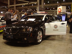
Prototype Pontiac G8 for LAPD According to media reports from the the Frankfurt motor show General Motors is planning to sell Australian made Commodore cars to US law enforcement agencies.

In March when speaking at a public safety communications conference in Sydney, I tried out several prototype police cars. One was a Los Angeles Police Department (LAPD) squad car (LAPD officers were speaking at the conference).

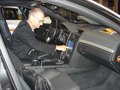
Touch screen in Prototype Pontiac G8 for LAPDThe vehicle was fitted with a large portrait format touch screen in the centre console, replacing the clutter of controls common in police vehicles. The Commodore is a large vehicle, allowing room for the equipment carried in police cars. There was also an upgraded electrical supply fitted.

While I only got to sit in the stationary LAPD car, I did have a ride in the back of one of the unmarked cars. This was fitted with discrete LED red and blue lights and also had recharging stations for police torches in the back. In place of the touch screen this car had a compact keyboard in a holster on the side of the transmission tunnel. The officer in the passenger seat could pull the keyboard out of the holster and put it on their lap, using the console mounted screen for looking up the police database.

The LAPD prototype was based on the US export version of the Holden commodore. The vehicle was branded as a GM Pontiac G8 for the US market. This was dropped after GM's financial difficulties. But the Commodore is still engineered for construction in left hand drive for the US market. As an example, the instrument cluster for the driver's side of the car is designed to be swapped with the glove box on the passenger's side. Also the handbrake on the driver's side of the transmission tunnel is swapped with a grab handle on the passenger's side. This would allow a small number to be made for US police use.

Labels: , , , , ,

Sunday, September 13, 2009

Victorian Government asking for mobile phone bushfire system

The Victorian Government has issued a Request for Information (RFI) for "Location Based Identification of Active Mobile Handsets for Emergency Notification Purposes (SS-06-2009, 6 August 2009, closing 28 October 2009). There is a four page document (pdf format, 572 kBytes). Appended is an excerpt from the Statement of Requirements in the document.

There some obvious flaws in the RFI. The first is that the RFI is assuming a particular technical solution to the problem of altering people to an emergency. Specifically the RFI refers to Location Based Identification of Active Mobile Handsets". This assumes it is feasible, legal, safe and necessary to identify where handsets are, in order to issue a localised bushfire warning. As I have discussed in a number of presentations this year, this is not necessary and may not be desirable. A further problem is the the time for the RFI, to which a decision is not expected until late February 2010.

Victoria has an urgent need for bushfire emergency warning systems. By selecting a solution which will involve complex technical and legal issues and by cutting off alternatives which may be better, even before an RFI is issued, the Victorian Government is delaying the implementation of a workable system and thus placing at further risk its citizens. There is a risk that a complex system will take longer to produce and will be less reliable. Also producing a system which too precisely tracks where citizens are will create privacy concerns and may also give a false sense of the precision of the information which citizens will receive. Victoria should aim to build a simple robust system first. In addition Victoria has to build and test a clear chain of command for who can decide to issue warnings using the system.

RFI Part B – Statement of Requirements

Department of Treasury and Finance – Government Services Group

Request for Information for Location Based Identification of Active Mobile Handsets for Emergency Notification purposes

1.OVERVIEW
COAG has agreed to take immediate steps to enhance Australia’s natural disaster arrangements through the development of a telephone-based emergency warning system that will enable the States and Territories (the States) to deliver warnings to landline and mobile telephones, based on the billing address of the subscriber, to be operational by October 2009 and to undertake further research into a capability to deliver warnings based on the location of a mobile telephone.
Communication with potentially affected individuals before, during and after emergencies is critical and it is an area where the States and the emergency service organisations can leverage telecommunications technology to greater advantage as the provision of information to individuals during emergencies can make a critical difference.

The delivery of emergency warnings to landline and mobile telephones, based on the billing address of the subscriber, component is being addressed through the NEWS (National Emergency Warning System) Request for Tender (RFT) for all States except Western Australia. Western Australia will deliver their emergency warning messages using WA StateAlert.

We recognize that individuals have become increasingly mobile and we acknowledge that location based identification of active mobile handsets within a geographically defined emergency area will provide an efficient and effective method to notify potentially affected individuals.

To further our research into the identification of location based active mobile handsets for the purpose of emergency warning notification, and to potentially supplement the NEWS, we are seeking an understanding of your wireless location based capability in this regard.

This document describes the background for seeking an understanding of location based identification of active mobile handsets, for the purpose of emergency warning notification, with a view to incorporating this technology within the NEWS.

2.Background

Both Federal and State government have undertaken research to determine the most effective method of notifying individuals of impending or existing emergency events that could have an impact on the welfare of individuals within the geographically defined emergency area.

Consumer trends reveal that the preferred method of communication with an individual is the mobile telephone.

Australia has a mobile telephone saturation point in excess of 100% and this is currently increasing.1

Australia: Population and Cellular Market Penetration ...


At the same time the domestic penetration of fixed line telephone is decreasing. ...

3.Requirements

It is our aim to understand current and future capability of mobile location based services that are able to be provided by a solution provider.
We would further like to understand your view of network or other component enhancements that may be necessary to enable the location based identification of active mobile handsets for the purpose of emergency warning notification.
We would also like to understand the current impediments that exist which may prevent location based technology from being utilised to identify active mobile handsets within a defined emergency area.

These expectations may vary based on locality of emergency event and the type of emergency event. These expectations will be further explored based on requirement for accuracy, speed of delivery, delivery indicator and network load. We aim to understand what degree of certainty and accuracy can be achieved through the different methods of targeting location based active handset messaging.

Emergency event types may dictate a requirement for outbound messages to be delivered to targeted active mobile handsets. This requirement may range from naturally occurring events, with an amount of lead time before the event is predicted to occur through to more urgent man-made, instantaneous emergency events concentrated in Capital city Central Business District precincts.

Examples of the message volumes for mass dissemination are in the range of 1,000 messages for specific public safety messages where precision of accuracy is required, 5,000 for town or shire type notification, 20,000 for metropolitan targeted warning, 50,000 for widespread urban events such as flooding through to 100,000 upwards for extreme and CBD centric events.

Emergency warning messages may be disseminated using either voice or text.
It will be essential to understand the capability and precision of location based identification of active mobile handsets across CBD, metropolitan, urban and rural localities.

This understanding of capability across different cell density and cell types will further allow emergency service organisations to structure their emergency warning processes and procedures appropriately and with a clear understanding of what the technology can provide based on locality and requirement of the emergency event type. This exercise may require a collaborative and open approach between government with

Respondents.
The table below illustrates various emergency event types and fundamental requirements to be met as part of delivering that type of emergency warning.

Table 1

Wireless Technology Characteristics ...

Response Required

As location based services mature, and for certain emergency event types, it would be envisaged that:

  • the technology will have the ability to receive notifications about any new mobile devices entering a previously specified emergency area to alert the user that, for example, an emergency services vehicle has arrived at a location, or a civilian has entered the area and may be unaware of the emergency
  • the technology will include the ability to receive notifications for any mobile devices exiting the defined emergency area. This could facilitate the creation of an evacuation list of people who are still remaining in the emergency area
  • the technology will be able to locate specific mobile devices in both 2G and 3G networks, and overlay their position onto a map.
  • the technology will have the ability to provide sufficient privacy and authentication checking mechanisms to ensure mobile location security

This understanding of a Respondent’s ability to identify location based active mobile handsets will enable governments to consider any future adoption of this capability ...


From: "Location Based Identification of Active Mobile Handsets for Emergency Notification Purposes, SS-06-2009, Request for Information (RFI), Department of Treasury and Finance, Victorian Government, 6 August 2009


Labels: , , ,

Tuesday, September 01, 2009

Telstra Global Operations Centre

Telstra's Global Operations Centre (GOG) in Melbourne appears to be too large to be effective. David Neiger's Article in August 2009 Australian Personal Computer magazine ("Telstra's massive nerve centre exposed") ,is accompanied by photos showing a conventional command centre room.

The GOC room is rectangular, with a wall of monitors at one end straight rows of operator stations. The room is divided into two halves with a walkway down the middle, which wastes the most valuable space of the room (the center). There are five operators in each row in half the room, with ten rows: one hundred operator stations in total.

Most operators have four large LCD screens in front of them. Because of the width of the screens, the operators appear to be more widely spaced than is needed, or useful, for effective work. The spacing could be reduced by one quarter, to allow them to work together more effectively. It is questionable if one operator could usefully observe four separate LCD screens around them. Removing one screen would likely improve the effectiveness of the station. A better option would be to replace all three monitors with one large wide screen monitor.

The desks also appear to be 50% deeper than needed, most likely due to having been designed for bulky obsolete CRT display screens.

There are supplementary monitors suspended from the ceiling along the sides of the room. These are likely needed as the operators at the back of the room would not be able to read what is on the board at the front.

Making the desks less deep, placing the operators closer together and removing the central walkway would allow the size of the room to be halved. This would increase the efficiency of the operation, as the operators would be able to more easily work as a team, as well as save very expensive floor space. Curving the row of desks slightly, would also allow the operators easily see each other, as is done in the NATO Combined Joint Operations Centre (CJOC) in Kabul.

Tesltra has a more modestly sized Managed Network Operations Centre in Sydney. The MNOC has a 16.7 metre video wall and provision for 42 operator stations.

Labels: , ,

Friday, August 28, 2009

Location Based Services for Emergency Management

Today I was interviewed by Anas Aloudat at the University of Wollongong for new research on Location-Based Services for Emergency Management. This is very timely work, give the issue of alerting for bushfires.

Already published:
  1. "Location-Based Services for Emergency Management: A Multi-Stakeholder Perspective", Anas Aloudat, K. Michael, and Roba Abbas. The Eighth International Conference on Mobile Business (ICMB 2009). Dalian, China: IEEE Computer Society, 2009. 1-6.
  2. "The Current State of Commercial Location-based Service Offerings in Australia", Roba Abbas, K. Michael, M.G. Michael, and Anas Aloudat. The Eighth International Conference on Mobile Business (ICMB 2009). Dalian, China: IEEE Computer Society, 2009. 1-8.
  3. "Location-Based Services in Emergency Management- from Government to Citizens: Global Case Studies", A. Aloudat, K. Michael, and J. Yan.Recent Advances in Security Technology (1 ed). Ed. P. Mendis, J. Lai, E. Dawson and H. Abbass. Canberra, Australia: Australian Homeland Security Research Centre, 2007. 190-201.

Labels: , , ,

Monday, August 17, 2009

Victorian Bushfires Royal Commission Interim Report

The 2009 Victorian Bushfires Royal Commission Interim Report was released today. The recommendations relating to the use of ICT, the Internet and the web are well thought out. The report is in the form of a set of reasonably well formatted, efficiently web pages.

The report executive summary scored 32 out of 100 on the W3C mobileOK Checker, which is better than many web pages. One flaw is that images for the report have been marked with hyperlinks labelled "CLICK FOR IMAGE". It would have been better to include a small preview image or have a link on the caption of the image. The executive summary failed an automated web accessibility test (WCAG 2) with 517 problems, which are easily correctable.
ICT related recommendations:
  • RECOMMENDATION 4.5: The State ensure that the Standard Emergency Warning Signal (SEWS) be used in Victoria to precede each bushfire warning or group of warnings for bushfires that are dangerous or extremely dangerous, particularly for a fire that is burning out of control and poses a threat to human life, subject to appropriate limits on the maximum frequency of use.
  • RECOMMENDATION 4.8: The Australian Government, Council of Australian Governments and the State determine whether it is technically possible to implement the second phase of the national telephony-based warning system (that is, the delivery of warning messages to mobile phones based on the physical location of a handset at the time of the emergency) with a view to implementation for the 2009–10 bushfire season.
  • RECOMMENDATION 5.2: The Bureau of Meteorology include the Forest Fire Danger Index and the Grass Fire Danger Index in its fire weather warnings and general weather forecasts on its website and in material distributed to the media.
  • RECOMMENDATION 5.3: The State ensure that a single, multi-agency portal for bushfire information be established that uploads information simultaneously to both CFA and DSE websites.

Labels: , , , ,

Wednesday, August 12, 2009

Warning Systems For University Campuses

"Deciphering the New Federal Integrated Public Alert and Warning System" by Dewitt Latimer provides a useful overview of issues with providing emergency warning messages on university campuses. It is written from the US point of view and uses terminology relating to US federal legisation for issueing energy wanrings to citizens (with the emphasis being on how to relay these to people on a campus, susally via SMS on a mobile phone). But the article will be of interst to those outside the USA.
"This research bulletin explores the history of nationwide notification leading up to the new federal government Integrated Public Alert and Warning System (IPAWS), as well as the Commercial Mobile Alert System (CMAS) delivery process and message format and content. It also examines the potential impact of IPAWS and CMAS on higher education and suggests actions that colleges and universities may wish to take."
Citation: Latimer, Dewitt. “Deciphering the New Federal Integrated Public Alert and Warning System” (Research Bulletin, Issue 16). Boulder, CO: EDUCAUSE Center for Applied Research, 2009, available from http://www.educause.edu/ecar.

Labels: , , ,

Tuesday, August 11, 2009

Indian Ocean Tsunami Warning Cancelled

The Pacific Tsunami Warning Center (PTWC) issued a warning for the Indian Ocean at 2005 UTC (bulletin number 1). This followed a 7.7 earthquake near the Andaman Islands. A tsunami was predicted to arrive in towns in the islands within 15 minutes, and on the Indian mainland including KAKINADA within an hour, and later: MYANMAR, INDONESIA, THAILAND, BANGLADESH. The JAPAN METEOROLOGICAL AGENCY (JMA) issued a similar bulletin at 2025. The PTWC issued a second bulletin at 2105Z saying a tsunami was generated, but a third bulletin at 2124Z corrected this saying no tsunami had been observed. At 2211Z PTWC cancelled the Tsunami watch. A problem with this process is the difference in times and details between the Japanese and US warnings. The JMA seems to issue fewer, later and less detailed bulletins.

Labels: , ,

Thursday, July 16, 2009

Australian Tsunami Warning Issued

The Joint Australian Tsunami Warning Centre issued a Land Warning for Lord Howe Island at 10:45 PM EST on 15 July 2009 and a Marine Warning for much of south east Australia. This followed an earthquake off the south of New Zealand at 0923Z 15 JUL 2009. The media were requested to use the Standard Emergency Warning Signal (SEWS) for Lord Howe Island, but not mainland Australia.

At 12:14 AM EST on Thursday 16 July 2009 threat for Lord Howe Island was downgraded to a Marine Warning and use of the SEWS cancelled. One anomaly with this was that the message for Lord Howe Island (IDY68035) used different text to those for the mainland (IDY68028). The mainland messages said "Marine Warning", whereas the Lord Howe Island message did not contain that phrase. This may seem a minor point, but a lack of use of standard wording can cause dangerous misunderstandings.

Unlike the Pacific Tsunami Warning Center, the Australian Centre does not appear to provide a public archive of issued messages, so I have included two in this posting for research purposes.

For a discussion of warning systems see my "National Bushfire Warning System", Seminar, College of Engineering and Computer Science, ANU, Canberra, 16 April 2009.

** Land and Marine Threat Tsunami Warning is current for Lord Howe Island. **

THERE IS A LAND AND MARINE TSUNAMI WARNING CURRENT FOR LORD HOWE ISLAND.

IDY68034
Australian Government Bureau of Meteorology

MEDIA:
PLEASE USE STANDARD EMERGENCY WARNING SIGNAL (SEWS)
TOP PRIORITY FOR IMMEDIATE AND FREQUENT BROADCAST
********************************************************************************

TSUNAMI WARNING NUMBER 3 FOR LORD HOWE ISLAND
Issued by the Joint Australian Tsunami Warning Centre (JATWC) at
10:45 PM EST on Wednesday 15 July 2009

********************************************************************************

TSUNAMI THREAT TO LOW-LYING COASTAL AREAS AND THE MARINE ENVIRONMENT

********************************************************************************
SUMMARY:

Tsunami warning for LORD HOWE ISLAND.

An undersea earthquake of magnitude 7.9 (Latitude 45.960S Longitude 166.470E )
has occurred at 07:22 PM EST on Wednesday 15 July 2009 near OFF W. COAST OF
S. ISLAND, N.Z..

For low-lying coastal areas there is a threat of MAJOR LAND INUNDATION,
FLOODING, DANGEROUS WAVES AND STRONG OCEAN CURRENTS for several hours from
09:30 pm (EST) Wednesday.

People in affected areas are strongly advised by the NSW STATE EMERGENCY
SERVICE to go to higher ground or at least one kilometre inland.

For all threatened areas, people are advised to get out of the water and move
away from the immediate water’s edge.

Next update will be issued by 11:45 PM EST on Wednesday 15 July 2009

For latest and further information call 1300 TSUNAMI (1300 878 6264) or visit
www.bom.gov.au

********************************************************************************
DETAILS:

TSUNAMI THREAT TO LOW-LYING COASTAL AREAS
A threat of MAJOR LAND INUNDATION, FLOODING, DANGEROUS WAVES AND STRONG OCEAN
CURRENTS exists for several hours from 09:30 pm (EST) Wednesday.

COMMUNITY RESPONSE ADVICE FROM THE NSW STATE EMERGENCY SERVICE:

- The NSW STATE EMERGENCY SERVICE has ordered the evacuation of low-lying parts
of coastal towns and villages.

- People are strongly advised to go to higher ground, at least ten metres
above sea level, or if possible move at least one kilometre away from all
beaches and the water's edge of harbours and coastal estuaries.

- Take only essential items that you can carry including important papers,
family photographs and medical needs.

- It may be in your own interests to walk to safety if possible to avoid
traffic jams.

- If you cannot leave the area take shelter in the upper storey of a sturdy
brick or concrete multi-storey building.

- Boats in harbours, estuaries or shallow coastal water should return to
shore. Secure your boat and move away from the waterfront.

- Vessels already at sea should stay offshore in deep water until further
advised.

- Do not go to the coast to watch the tsunami, as there is the possibility of
dangerous, localised land inundation of the immediate foreshore.

- Check that your neighbours have received this advice.

CAUTION:
Tsunami waves are more powerful than the same size beach waves, with the first
wave not necessarily being the largest.

Low-level effects may be observed in neighbouring coastal areas. People are
advised to take care.

TSUNAMI SOURCE:
An undersea earthquake of magnitude 7.9 (Latitude 45.960S Longitude 166.470E )
has occurred at 07:22 PM EST on Wednesday 15 July 2009 off W. COAST OF S.
ISLAND, N.Z.

Sea level observations have confirmed a tsunami has been generated.

Tsunami has been observed at Spring Bay in TAS at 10:05pm and at Port Kembla in
NSW at 10:06pm.

The NEXT UPDATE will be issued by 11:45 PM EST on Wednesday 15 July 2009

FOR LATEST AND FURTHER INFORMATION:
Call 1300 TSUNAMI (1300 878 6264) or visit www.bom.gov.au

FOR EMERGENCY ASSISTANCE:
Call the NSW STATE EMERGENCY SERVICE on 132 500

********************************************************************************

EST = Eastern Standard Time
CST = Central Standard Time = EST - 30 minutes
WST = Western Standard Time = EST - 2 hours

The JATWC is operated by the Australian Bureau of Meteorology and Geoscience
Australia
********************************************************************************

** Marine Threat Tsunami Warning is current for Norfolk Island. **

THERE IS A MARINE TSUNAMI WARNING CURRENT FOR NORFOLK ISLAND.

IDY68035
Australian Government Bureau of Meteorology

MEDIA:
NO USE OF STANDARD EMERGENCY WARNING SIGNAL (SEWS)
TOP PRIORITY FOR IMMEDIATE AND FREQUENT BROADCAST
********************************************************************************

TSUNAMI WARNING NUMBER 3 FOR NORFOLK ISLAND
Issued by the Joint Australian Tsunami Warning Centre (JATWC) at
01:47 AM NFT on Thursday 16 July 2009

********************************************************************************

TSUNAMI THREAT TO THE MARINE ENVIRONMENT

********************************************************************************
SUMMARY:

Tsunami warning for the marine environment of NORFOLK ISLAND.

An undersea earthquake of magnitude 7.9 (Latitude 45.960S Longitude 166.470E )
has occurred at 07:22 PM EST on Wednesday 15 July 2009 off W. COAST OF S.
ISLAND, N.Z.

Possibility of DANGEROUS WAVES, STRONG OCEAN CURRENTS AND SOME LOCALISED
OVERFLOW ONTO THE IMMEDIATE FORESHORE from now until 2:30am local time
Thursday.

Although major evacuations are not required, people are advised to get out of
the water and move away from the immediate water's edge.

Next update will be issued by 02:47 AM NFT on Thursday 16 July 2009

For latest and further information call 1300 TSUNAMI (1300 878 6264) or visit
www.bom.gov.au

********************************************************************************
DETAILS:

A threat of DANGEROUS WAVES, STRONG OCEAN CURRENTS AND THE POSSIBILITY OF SOME
LOCALISED OVERFLOW ONTO THE IMMEDIATE FORESHORE exists from now until 2:30am
local time Thursday.

COMMUNITY RESPONSE ADVICE FROM THE NORFOLK ISLAND POLICE :

- While major evacuations are not required, people are advised to get out of
the water and move away from the immediate water's edge of harbours, coastal
estuaries, rock platforms and beaches.

- Boats in harbours, estuaries or shallow coastal water should return to
shore. Secure your boat and move away from the waterfront.

- Vessels already at sea should stay offshore in deep water until further
advised.

- Do not go to the coast to watch the tsunami, as there is the possibility of
dangerous, localised flooding of the immediate foreshore.

- Check that your neighbours have received this advice.

CAUTION:
Tsunami waves are more powerful than the same size beach waves, with the first
wave not necessarily being the largest.

Low-level effects may be observed in neighbouring coastal areas. People are
advised to take care.

TSUNAMI SOURCE:
An undersea earthquake of magnitude 7.9 (Latitude 45.960S Longitude 166.470E )
has occurred at 07:22 PM EST on Wednesday 15 July 2009 near OFF W. COAST OF
S. ISLAND, N.Z..

Sea level observations have confirmed a tsunami has been generated.

Tsunami has been observed at Spring Bay in TAS at 10:05pm and at Port Kembla
in NSW at 10:06pm.

Tsunami threat levels are expected to gradually decrease from 2:30am local time
Thursday.

The NEXT UPDATE will be issued by 02:47 AM NFT on Thursday 16 July 2009

FOR LATEST AND FURTHER INFORMATION:
Call 1300 TSUNAMI (1300 878 6264) or visit www.bom.gov.au

FOR EMERGENCY ASSISTANCE:
Call the NORFOLK ISLAND POLICE on 977

********************************************************************************

EST = Eastern Standard Time
CST = Central Standard Time = EST - 30 minutes
WST = Western Standard Time = EST - 2 hours

The JATWC is operated by the Australian Bureau of Meteorology and Geoscience
Australia
********************************************************************************

Labels: , , ,